View of Ailcy Hill, Ripon, Yorks.© Sarah Semple
people, place & space
What can we learn about social organisation, familial ties, identitiy and belief?
What temporal and spatial variations can be identified for health, wealth, welfare and mortuary rites?
How did cemetery placement connect to landscape, earlier features, and resources?
What landscape strategies were used by communities and elites in funerary ritual?
How did this relate to the claiming and defining of territories?
We will use the data gathered in the project in a Geographical Information System (GIS) to explore these questions.
|
|
the sites |
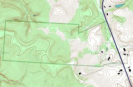
Mapping the data |
|
239 excavated burial sites have been identified across the studiy area, dating to AD 300 - 800.
|
All the datasets collected during the project will be brought together in Geographical Information System (GIS) to explore statial and temporal patterns.
|
