Welcome to the People and Place: The Making of the Kingdom of Northumbria 300-800 CE project blog. We will be using this space to update you on our project news and progress and upcoming publications. Our team of six researchers over the next three years will together undertake a major in-depth exploration of the full suite of burial evidence for the entire of the kingdom of Northumbria. Our project starts in AD 300, allowing us to capture information on burial rites and traditions in the century before the collapse of Roman military authority. We will chart and interrogate all burial evidence from this point to c AD 800, allowing investigation of the changing rites and traditions in their landscape context across a period of political, social and religious change. A major facet of the project is the integration of scientific applications – osteological and palaeopathological assessment of a large sample of skeletal remains, isotopic analyses and the applications of high resolution AMS dating.
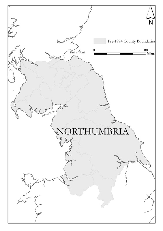
Today the blog is all about my work on the project. As a landscape archaeologist and GIS specialist, one of my primary tasks is the mapping of all known burials within the extent of the kingdom of Northumbria. One of the first steps has therefore been to define the spatial boundaries for the project. Northumbria’s boundaries were fluid, expanding or contracting according to conquests and losses. David Rollason notes the approximate boundaries of Northumbria at their greatest extent stretched from the North to Irish Sea and from the Cheshire and the Humber in the south to the Galloway and the Firth of Forth in the north (Rollason 2007, 2-7). Bede described in Historia Eccesiastica Gentis Anglorum in AD 731, that during King Edwin’s reign '[…] if a woman with a newborn child wanted to walk throughout the island from sea to sea she would meet no harm (HE II, 16, 191)', implying that Northumbrian royal control extended from the North to Irish Seas. While the coastlines offer a robust boundary for our study area to the east and the west, defining a cut off for the edges of the kingdom at its greatest extent to north and south is more difficult. At the outset therefore, the project is taking in data for England and Scotland from the following counties outlined below, purposely drawing in data from the broadest possible extent to reflect the fluid nature of the limits of this kingdom over time. Northumbria is noted for an imbalance in focus with much more research conducted on the eastern heartlands of the kingdom rather than the west (Clark 2011, 113). We hope to remedy this although a paucity of funerary data and issues of survival are well recognised challenges for the north west of England and the Scottish Borders. Our current working geographic extent can be seen here, boundaries are predicated on the pre-1974 boundaries for England and Scotland. Our scope allows us to include some assessment of the Peak District burials and bring in important burial data sets from the western Scottish borders.
Today the blog is all about my work on the project. As a landscape archaeologist and GIS specialist, one of my primary tasks is the mapping of all known burials within the extent of the kingdom of Northumbria. One of the first steps has therefore been to define the spatial boundaries for the project. Northumbria’s boundaries were fluid, expanding or contracting according to conquests and losses. David Rollason notes the approximate boundaries of Northumbria at their greatest extent stretched from the North to Irish Sea and from the Cheshire and the Humber in the south to the Galloway and the Firth of Forth in the north (Rollason 2007, 2-7). Bede described in Historia Eccesiastica Gentis Anglorum in AD 731, that during King Edwin’s reign '[…] if a woman with a newborn child wanted to walk throughout the island from sea to sea she would meet no harm (HE II, 16, 191)', implying that Northumbrian royal control extended from the North to Irish Seas. While the coastlines offer a robust boundary for our study area to the east and the west, defining a cut off for the edges of the kingdom at its greatest extent to north and south is more difficult. At the outset therefore, the project is taking in data for England and Scotland from the following counties outlined below, purposely drawing in data from the broadest possible extent to reflect the fluid nature of the limits of this kingdom over time. Northumbria is noted for an imbalance in focus with much more research conducted on the eastern heartlands of the kingdom rather than the west (Clark 2011, 113). We hope to remedy this although a paucity of funerary data and issues of survival are well recognised challenges for the north west of England and the Scottish Borders. Our current working geographic extent can be seen here, boundaries are predicated on the pre-1974 boundaries for England and Scotland. Our scope allows us to include some assessment of the Peak District burials and bring in important burial data sets from the western Scottish borders.
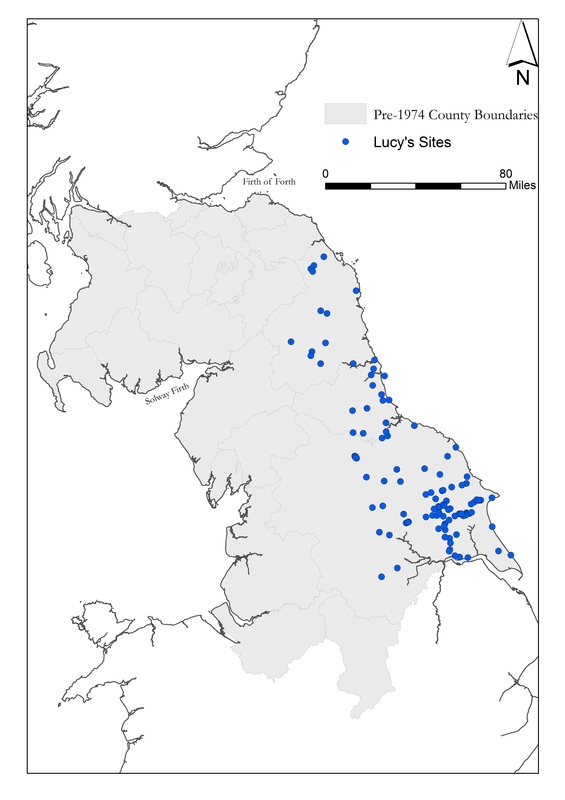
Building on past gazatteers and databases, such as those constructed by Sam Lucy (1998; 1999) and Helen Geake (1997), data is being drawn from regional research agendas, published handlists and catalogues and HeR and grey literature. The latter will require careful handling and detailed ‘cleaning’ to ensure we get the most productive and usable data sets possible for the initial GIS assessment. The project will include reassessment of graves and cemeteries in terms of form and location, the cataloguing of each individual burial facilitating a ‘census’ for the kingdom over time, re-visitation of all artefactual assemblages in terms of object type and date as well as scientific analyses of the remains of over 200 individuals.
East Yorkshire will be used as a pilot study to test the database currently under construction by Dr Sue Harrington. This integrated relational database assigns unique values to individual burials along with information related to the depositional patterns, morphological characteristics and artefactual evidence of each grave. This is integrated into the GIS database I am designing in order to query spatial aspects of the data.
Clark, F 2011 'Thinking about Western Northumbria', in D Petts and S Turner (eds), Early Medieval Northumbria: Kingdoms and Communities, AD 450-1100. Brepols.
Lucy, S 1999 'Changing burial rites in Northumbria AD 500–750', in J Hawkes and S Mills (eds), Northumbria's Golden Age. Sutton Publishing.
Rollason, D 2007 'Northumbria: A failed European kingdom', in R Colls (ed), Northumbria: History and Identity, 547-2000. Phillamore Publishing.


 RSS Feed
